 Cre8Travel
CRE8TRAVEL · NEW YORK PLACES
Cascade Valley State Forest
Cascade Valley State Forest: Beaver Ponds, Hemlock and Higher Ground
Discover
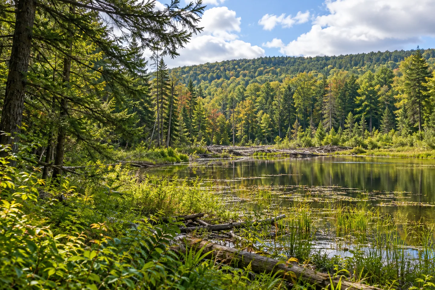
Cascade Valley State Forest fits several different woodland scenes into 533 acres in Windsor, Broome County. Hemlock follows lowland stream corridors, red pine plantations mark another kind of tree cover, and hardwoods occupy the higher ground. The result is a place to notice transitions: water to hillside, planted trees to natural stands, and the roadside to steeper terrain beyond it.
The forest was acquired from one landowner in 1937. Its name comes from a tributary flowing through the property and eventually reaching Cascade Creek. That gives the name a local explanation without turning it into a promise of waterfalls. Follow the actual map and documented features rather than assuming that a forest named Cascade must contain a particular cascade or a signed waterfall walk.
A multiple-use recreation trail crosses the middle of the property from east to west, east of Cascade Valley Road. Its orientation is a useful starting point for planning a walk, although it does not establish that every feature mentioned in the forest description lies directly beside that trail. The road itself passes through the forest, and public land lies on both sides. DEC identifies a northern parking area and a southern pull-off along this approach.
Water contributes a second thread. There are two beaver-pond wetlands. The western one, beside Cascade Valley Road, covers about five acres. The other lies east of the road along the southern boundary. Hawks, herons, ducks and geese are among the wildlife associated with these wet places. Watch without turning a habitat description into a guarantee of sightings, and let the relationship between open water and surrounding woodland hold your attention even when animals are out of view.
The elevation rises from about 1,300 feet near the road to 1,688 feet on a hilltop half a mile east of it. A steep hill to the southeast contains mature hardwoods near layered stone outcrops. These are specific reasons to be interested in the upper ground, but they do not establish a panoramic overlook, a marked summit route or a particular geological age. For photography, the contrast between stone layers and tree trunks offers a subject in its own right.
Forest management is part of this landscape's story. DEC describes a thinned, roughly 100-acre natural stand with high-quality timber and discusses harvesting and thinning as management tools. Older trees provide cavities used by squirrels, owls, raccoons and fisher. Keep those two ideas separate: the presence of cavity trees is documented, while the suggestion that thinning itself creates every cavity would go beyond the description. Management intentions are also not a timetable of work happening during your visit.
Primitive camping requires planning rather than an assumption of campground facilities. DEC's guidance specifies a 150-foot setback from roads, trails and water, with a ranger permit for stays longer than three nights or groups of ten or more. Check current conditions and rules before departure, particularly if combining activities or using unfamiliar ground.
Hawkins Pond and Skyline Drive state forests appear in DEC's nearby-land list; Binghamton is identified for amenities. Cascade Valley belongs to the broader Broome State Forests management unit, but that administrative connection does not make the separate forests one continuous route. Give this property time on its own terms: a modest area with an unusually clear progression from beaver ponds and streamside hemlock to hardwoods and layered rock.
Fun facts
- The 533-acre forest was acquired from one landowner in 1937.
- Its name refers to a tributary that eventually reaches Cascade Creek.
- The western beaver pond covers about five acres.
- Elevation ranges from about 1,300 feet near the road to 1,688 feet on an eastern hilltop.
- Mature hardwoods grow near layered stone outcrops on the steep southeastern hill.
Before you go
- Check the official map before leaving the east–west recreation trail; individual features are not all documented as trail-side stops.
- Use the identified parking area or pull-off along Cascade Valley Road, rather than assuming every roadside location permits stopping.
- Plan for the documented steep southeastern ground if considering that part of the forest.
- Check current camping setbacks and permit requirements before an overnight stay.
- Practice Leave No Trace around the wetlands and woodland.
Nearby & related places
- Unranked nearby state-land selection: Hawkins Pond State Forest — listed by DEC for the Cascade Valley area.
- Skyline Drive State Forest — another nearby state-land option listed by DEC; plan its access separately.
Capture
- Compose a wetland image around water, vegetation and woodland, without depending on a bird appearing.
- Where reached through appropriate public access, contrast layered stone with the vertical forms of mature hardwoods; an open panorama is not documented.
- Compare the texture of hemlock along stream corridors with the forest’s hardwood and red-pine cover.
 Beaver Pond State Forest
 Marsh Pond State Forest
 Melondy Hill State Forest
Social
Cascade Valley State Forest covers 533 acres in Windsor, Broome County. Its name follows a tributary that eventually reaches Cascade Creek. #Cre8Travel
A multiple-use trail crosses east to west through the middle of Cascade Valley State Forest, east of the road. Use the official map to plan individual stops. #Cre8Travel
Two beaver-pond wetlands add another dimension to Cascade Valley. The western pond beside Cascade Valley Road covers about five acres. #Cre8Travel
Hemlock-lined stream corridors, red pine plantations and upland hardwoods give Cascade Valley several woodland textures to compare. #Cre8Travel
Cascade Valley rises from about 1,300 feet near the road to 1,688 feet on an eastern hilltop. A high point does not automatically mean an open overlook. #Cre8Travel
Mature hardwoods meet layered stone on Cascade Valley’s steep southeastern hill. A composition can work through texture and shape rather than a distant panorama. #Cre8Travel
Older trees at Cascade Valley provide cavities for wildlife including squirrels, owls, raccoons and fisher. Look at habitat without expecting a guaranteed encounter. #Cre8Travel
Cascade Valley was acquired from one landowner in 1937. Which landscape detail would you notice first: the beaver ponds, hemlock or layered stone? #Cre8Travel
Hashtags